
A practical look at the newer flight display, existing GTN Xi navigators, and the upgrade options worth considering.
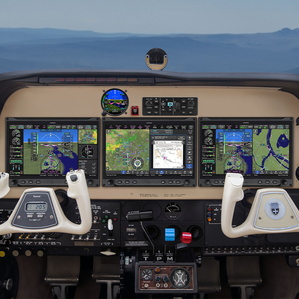
Your G3X Touch has served you well. It puts flight information, maps, synthetic vision and, when equipped, engine data in one place. So why consider an upgrade to Garmin AXIS?
The answer isn’t that the G3X suddenly stopped being capable. AXIS offers a newer display platform, a larger viewing area and additional ways to organize and understand information in flight. For some owners, it also presents an opportunity to simplify the radio stack. For others, the best approach is to keep the excellent equipment already installed and upgrade the display around it.
A larger view of the information that matters
AXIS is designed to bring primary flight information, maps, navigation, traffic, weather and engine data together, depending on how the aircraft is equipped. Its 11.6-inch display offers more screen area than the 10.6-inch G3X Touch display while sharing the same panel cutout and mounting points. The result is more room for the information a pilot wants to see without necessarily redesigning the entire panel.
That doesn’t make every upgrade a simple display swap. Wiring, compatible sensors, software, backup instruments and the aircraft’s approved installation all need to be reviewed before the work begins.
A clearer picture of your vertical flight path
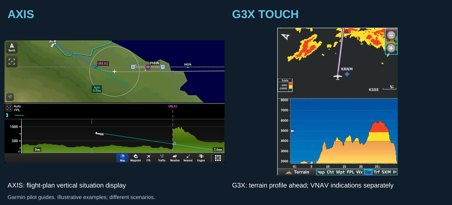
One feature worth a closer look is the AXIS Vertical Situation Display, or VSD. Think of it as a side view of the aircraft’s flight environment. Depending on the selected mode and available information, it can show terrain and obstacles along the current track or flight plan, as well as waypoints, altitude constraints and the vertical navigation profile.
For a pilot managing a descent or reviewing the route ahead, that view can make it easier to understand the relationship between the airplane, the planned path and surrounding terrain.
G3X Touch is not without vertical information: its terrain page has a Profile View, and the system provides vertical navigation indications. AXIS presents a different flight-plan-oriented vertical picture. Neither display replaces the pilot’s responsibility to verify altitude, terrain clearance, navigation guidance and the applicable procedures.
Synthetic vision and runway awareness
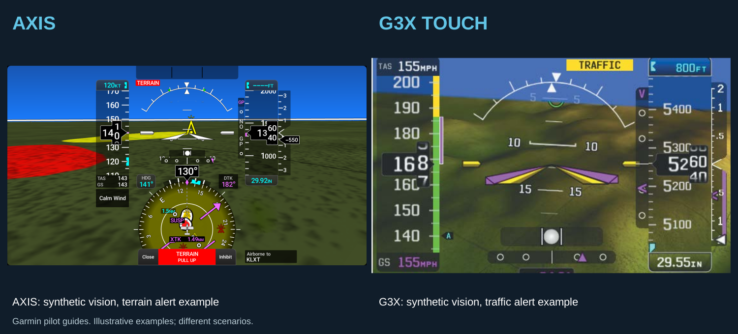
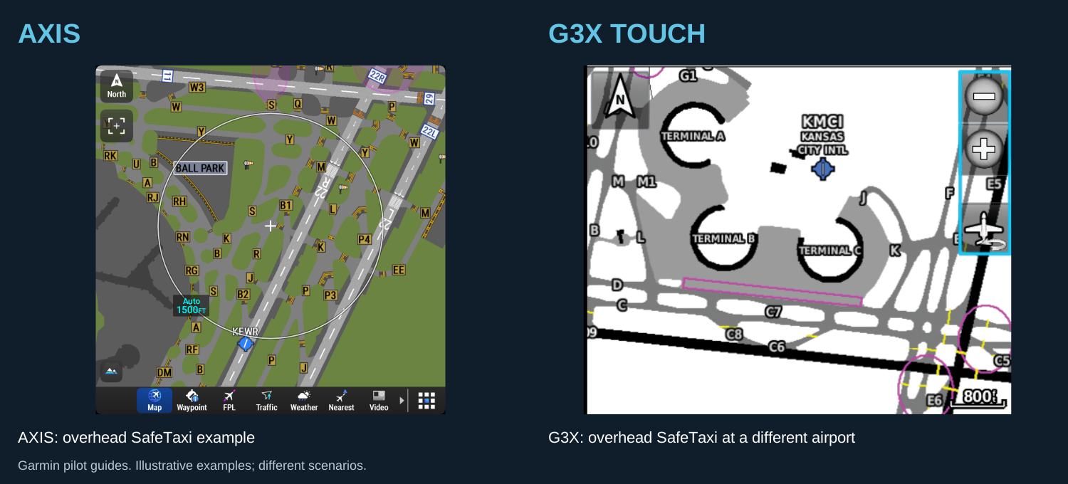
Both AXIS and G3X Touch include Garmin synthetic vision. AXIS also includes the 3D SafeTaxi feature, which can provide an expanded view of the airport environment when the required position information and database are available.
AXIS includes Runway Occupancy Awareness (ROA) in its base software. With a supported traffic source and appropriate runway data, ROA can alert a pilot to detected traffic that may occupy the runway during takeoff or landing. It is an aid to awareness—not a substitute for looking outside, monitoring the radio and following air traffic control instructions. A compatible traffic source matters: Garmin states that GDL 5X receivers do not provide ROA, and GNX 375 support is subject to a future update according to the Garmin guidance reviewed for this article.
Garmin’s optional SurfaceWatch enablement adds a different layer of runway monitoring, with alerts intended to help pilots avoid certain wrong-runway and runway-length errors. SurfaceWatch and ROA do different jobs; one should not be mistaken for the other.
Smart Glide: help when workload is highest
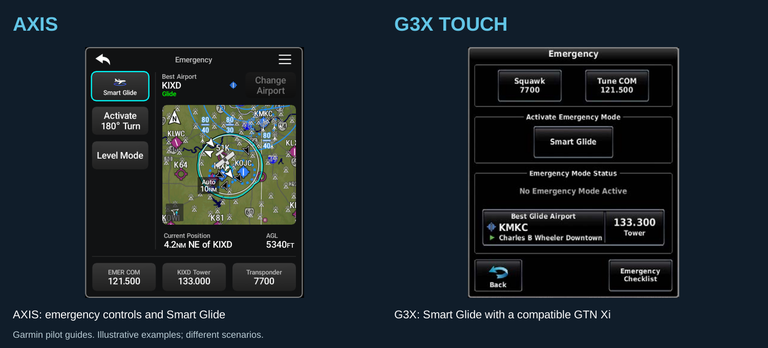
Smart Glide is included in the AXIS software baseline. When appropriately equipped and configured, the system can help identify a suitable airport after an engine power loss and assist the pilot with navigating toward it. A compatible autopilot can add guidance functions.
G3X Touch can also support Smart Glide when paired with a compatible GTN Xi navigator. The distinction is worth discussing during an upgrade: the available functions depend on the entire installed system, not just the label on one display. Smart Glide assists the pilot; it does not guarantee a safe landing or replace emergency training.
Do you need to replace your GTN Xi navigators?
Not necessarily. If your aircraft already has a GTN 750Xi and 650Xi, one sensible starting point is an AXIS GDU 116B display while retaining both navigators. The GTNs continue to provide the existing IFR GPS and NAV/COM functions, while the new display brings AXIS’s interface and display capabilities to the panel.
The 116B’s own internal GPS is intended for VFR navigation; it needs an appropriately approved external navigator for IFR GPS navigation. Keeping two GTN Xi units can preserve useful independent navigation and radio capability, subject to the final installation.
Another option is the GDU 116NC, which combines an IFR GPS navigator and NAV/COM functions with the AXIS display. An owner seeking a simpler stack could consider a 116NC and one retained GTN Xi. The right choice depends on redundancy, panel layout, equipment value, audio integration and installed cost—not just the number of boxes in the panel. The GDU 116C is another integrated option, providing IFR GPS and COM; the 116NC adds conventional NAV capability.
For an existing GTN Xi installation, Garmin specifies a high-speed data bus connection to AXIS. An existing GAD 29 may still have a role for applicable interfaces, but the shop must verify the actual wiring and configuration. Garmin also specifies matching navigation databases for AXIS and compatible navigators when synchronizing flight plans.
What costs extra—and does G3X already cover it?
Garmin lists three purchasable AXIS feature enablements: SurfaceWatch, ChartView and TAWS-B. They serve different purposes, and they are not the same as a database subscription or extra hardware. Whether they are worth the additional cost depends on how and where you fly, what equipment is already installed, and what is approved for your aircraft.
SurfaceWatch: runway monitoring and alerts
SurfaceWatch is intended to help prevent certain runway mistakes. Depending on the situation and available data, it can provide visual and aural alerts when an aircraft is lined up with the wrong runway, a runway that is too short for the performance data entered, or a taxiway. An owner might choose it for another layer of awareness at unfamiliar airports or complex airfields. It does not replace airport charts, outside observation, checklists or air traffic control instructions.
Does G3X cover it? G3X Touch offers SafeTaxi airport diagrams, but a diagram is not the same thing as SurfaceWatch runway-monitoring alerts. The G3X certified pilot guide reviewed for this article does not establish a standalone G3X SurfaceWatch enablement. If the aircraft has another navigator or system with runway-monitoring capability, ask the installer to verify its exact functions and how its alerts are presented. AXIS also offers Runway Occupancy Awareness in the base software when appropriately equipped; that traffic-related feature is separate from SurfaceWatch.
ChartView: Jeppesen charts on the display
ChartView lets a compatible display show Jeppesen electronic approach charts, arrivals, departures and airport diagrams, with aircraft position overlaid where supported. An owner who already uses Jeppesen charts, particularly one who wants that familiar chart presentation on the panel, may find the optional enablement useful. The AXIS ChartView key and the applicable Jeppesen chart-data subscription are separate purchases. Chart coverage and current pricing should be checked for the regions flown.
Does G3X cover it? Yes. The certified G3X Touch pilot guide describes ChartView as an option: it requires a purchased ChartView key and the appropriate Jeppesen data subscription. G3X also supports Garmin FliteCharts, a different chart option. An existing ChartView key or subscription should not be assumed to transfer automatically to a new AXIS installation; confirm the account, equipment and licensing with Garmin and Jeppesen.
TAWS-B: a certified terrain warning option
TAWS-B stands for Terrain Awareness and Warning System, Class B. When correctly enabled, installed and configured, it adds terrain-warning functions beyond simply displaying terrain or synthetic vision. The functions and alerts depend on the approved system configuration. An owner flying demanding terrain, or an operator whose aircraft and operation call for a Class B system, may value that added capability. Confirm whether any regulatory requirement actually applies before purchasing it; it is not automatically required for every aircraft.
Does G3X cover it? G3X Touch provides terrain awareness information, including terrain depiction and alerts described in its pilot guide, but that should not automatically be called a certified TAWS-B installation. A GTN Xi navigator can be equipped with optional TAWS-B, subject to its own enablement and approved installation; check the aircraft records and the alert/audio configuration before deciding whether an additional AXIS TAWS-B enablement is needed. Do not assume a feature on one unit is automatically enabled, displayed or approved on another.
For all three options, verify the current enablement price, database coverage, any required equipment or labor, and the aircraft-specific approval before ordering. The features assist the pilot; they do not replace sound judgment or required procedures.
Start with your mission, not a parts list
If your existing G3X and navigators meet your needs, keeping them may be the right answer. If you want more display area, AXIS’s vertical situation view, additional runway-awareness capabilities or an opportunity to simplify the panel, an upgrade deserves a careful look.
At Roger Wilco Aviation Services, we can review your aircraft, existing avionics, installation approvals and flying goals, then develop options that make sense for your panel and your budget. Contact us at service@rwas.team or 605-299-8178 to discuss your upgrade.
Editorial note: Capability depends on display model, software, installed equipment, databases and aircraft-specific approvals. Verify current Garmin documentation before finalizing an installation.
Sources: Garmin AXIS overview; AXIS feature enablements; AXIS Vertical Situation Display; G3X Touch certified pilot guide; G3X-to-AXIS interface guidance; AXIS database requirements.; Garmin GTN and GTN Xi terrain awareness; GTN Xi Pilot Guide